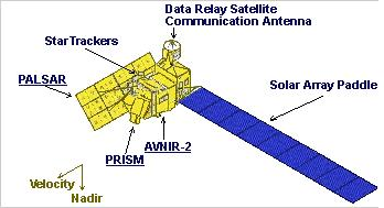
ALOS là một về tinh quan sát Trái đất của Nhật Bản, được phát triển bởi JAXA. ALOS được phóng thành công vào ngày 24 tháng 1 năm 2006 từ Trung tâm Vũ trụ Tanegashima.
ALOS có ba công cụ viễn thám, PRISM là một xạ toàn sắc với độ phân giải cao để có được dữ liệu địa hình bao gồm cả độ cao. AVNIR-2 là một xạ có thể nhìn thấy và hồng ngoại gần để quan sát khu đất ven biển và cung cấp cho độ phân giải không gian tốt hơn. PALSAR là một mảng pha loại L-band Radar khẩu độ tổng hợp, một bộ cảm biến vi sóng hoạt động cho điện toán đám mây miễn phí và quan sát ngày đêm đất.

Ngày 22 tháng tư năm 2011, vệ tinh ALOS đã sau hơn 5 năm hoạt động. Tuy nhiên, RESTEC vẫn tiếp tục phân phối ALOS dữ liệu lưu trữ cho người dùng cư trú tại các ADEN khu vực (ví dụ như Châu Âu, Châu Phi, Trung Đông).
Thông tin các về sản phẩm của vệ tinh ALOS:
|
No. |
Products and Services |
Outline |
Sensor |
Prosessing Lavel |
Unit |
Fomat |
Media |
|||||
|
1 |
ALOS standard Products |
Standard Products CEOS fomat |
PRISM |
Level 1A |
Approx.35kmx35km/scenne(Nadir)(Foward) Approx.35kmx70km/scenne(Nadir) |
CEOS |
Online CD-R |
|||||
|
Level 1B1 |
||||||||||||
|
Level 1B2 Geo-reference |
||||||||||||
|
Level 1B2 Geo-coded |
||||||||||||
|
AVNIR-2 |
Level 1A |
Approx.70kmx70km/scenne(Nadir) |
||||||||||
|
Level 1B1 |
||||||||||||
|
Level 1B2 Geo-reference |
||||||||||||
|
Level 1B2 Rough DEM correction(Japan area only) |
||||||||||||
|
PALSAR |
Level 1.0 |
Approx.70kmx70km/scenne(Fine) Approx.250km~350km x 250km~350km/scene(ScanSAR) Approx.30kmx70km/scenne(Polarimetric) |
||||||||||
|
Level 1.1 |
||||||||||||
|
Level 1.5 Geo-reference |
||||||||||||
|
Level 1.5 Geo-coded |
||||||||||||
|
2 |
Geo TIFF Products |
Geo TIFF fomat (L1B1:AVNIR-2/PRISM,L1.5:PALSAR) |
PRISM |
Level 1B2 Geo-reference |
Approx.35kmx35km/scenne(Nadir)(Foward) Approx.35kmx70km/scenne(Nadir) |
Geo TIF |
Online CD-R |
|||||
|
Level 1B2 Geo-coded |
||||||||||||
|
AVNIR-2 |
Level 1B2 Geo-reference |
Approx.70kmx70km/scenne(Nadir) |
||||||||||
|
Level 1B2 Geo-coded |
||||||||||||
|
PALSAR |
Level 1.5 Geo-reference |
Approx.70kmx70km/scenne(Fine) |
||||||||||
|
Level 1.5 Geo-coded |
||||||||||||
|
3 |
NITF Products |
NITF fomat (L1B1:AVNIR-2/PRISM,L1.5:PALSAR) |
PRISM |
Level 1B2 Geo-reference |
Approx.35kmx35km/scenne(Nadir)(Foward)(Backward) Approx.35kmx70km/scenne(Nadir) |
NÌTF |
Online CD-R |
|||||
|
Level 1B2 Geo-coded |
||||||||||||
|
AVNIR-2 |
Level 1B2 Geo-reference |
Approx.70kmx70km/scenne(Nadir) |
||||||||||
|
Level 1B2 Geo-coded |
||||||||||||
|
PALSAR |
Level 1.5Geo-reference |
Approx.70kmx70km/scenne(Fine) |
||||||||||
|
Level 1.5 Geo-coded |
||||||||||||
|
4 |
RPC Products |
Rational Polynomial Coffcient(RPC) file Optional products of PRISM 1B1 |
PRISM |
Level 1B1 |
Scene |
CEOS(PRISM)+Original(RPC) |
Online CD-R
|
|||||
|
NITF (PRISM+RPC) |
||||||||||||
|
Rational Polynomial Coffcient(RPC) file Optional products of PRISM or AVNIR-2 |
AVNIR-2 |
Level 1B2 Geo-reference |
Scene |
GeoTIFF(PRISM)+Original(RPC) |
||||||||
|
Level 1B2 Geo-coded |
||||||||||||
|
PALSAR |
Level 1B2 Geo-reference |
CEOS(AVNIR-2)+Original(RPC) |
||||||||||
|
Level 1B2 Geo-coded |
||||||||||||
|
Value Added products |
||||||||||||
|
No. |
Products and Services |
Outline |
Sensor |
Prosessing Lavel |
Unit |
Fomat |
Media |
|||||
|
ALOS Ortho Series |
||||||||||||
|
5 |
Ortho-Light |
Ortho-rectified image corresponding to GSI map scale 1/25000 (Japan area only) |
AVNIR-2 |
Ortho-retified image (Ortho-Light) |
Scene |
Geo TIFF |
Online |
|||||
|
Pan-sharpen |
||||||||||||
|
6 |
Ortho-Pro |
Precision ortho-rectified imge |
AVNIR-2 |
Precision ortho-rectified image (Ortho-Pro) |
Scene |
Geo TIFF |
Online |
|||||
|
Pan-Sharpen |
Rectangular/km2 (10.000 km2 ~) |
|||||||||||
|
AVNIR-2 |
Geo TIFF |
|||||||||||
|
Pan-Sharpen |
Rectangular/km2 (25.000 km2~) |
|||||||||||
|
ALOS DEM Series |
||||||||||||
|
7 |
DEM-Light |
Digital Surface Model by the image of PRISM from tow/three directions |
PRISM |
Ortho-retified image
|
Scene |
Geo TIFF |
Online |
|||||
|
8 |
DEM-Pro |
Digital Surface Model by the image of PRISM from tow/three directions |
PRISM |
Ortho-retified image
|
Rectangular/km2 (10.000 km2 ~) |
Geo TIFF |
Online |
|||||
|
PALSAR Global Ortho rectified Mosaic Data Set (PGM) |
||||||||||||
|
9 |
PGM(Resolution 10m) |
Global Mosaic Dataset with ortho-processing completel, using PALSAR FBD(HH,HV) |
PALSAR |
Ortho-retified image
|
Tile(1 degree) |
Geo TIFF |
Online |
|||||
|
Polygon specified (1.000 km2 ~) |
||||||||||||
|
10 |
PGM(Resolution 25m) |
Global Mosaic Dataset with ortho-processing completel, using PALSAR FBD(HH,HV) |
PALSAR |
Ortho-retified image
|
Tile(1 degree) |
Geo TIFF |
Online |
|||||
|
Polygon specified (1.000 km2 ~) |
||||||||||||
|
Other Products |
||||||||||||
|
11 |
On-Demand Products |
On-Demand Products (For example) Data Subsetting Services, 3-Dimensional Data, Birds view image, Movie,Panoramas.etc., Extraction of DMS data |
|
For details, please contact RESTEC”Data@restec.or.jp” |
||||||||
|
12 |
Analytical Data Services |
Analytical Data Services Nomalized Difference Vegetation Index Data(NDVI). Texture detection, Thematic Data, Various kinds of vegetation and land cover products, Change detection by the urban developments and/or environmental changes, SAR Interferometry Data, Stripe interference
|
|
For details, please contact RESTEC”Data@restec.or.jp” |
||||||||
|
13 |
Consultation & User Support Services |
Data Set Preparation Services and Support for Data Utilization |
|
For details, please contact RESTEC”Data@restec.or.jp” |
||||||||
Khi đặt mua các sản phẩm của tư liệu ALOS, khách hàng có thể đặt hàng trước các yêu cầu của tư liệu ảnh vệ tinh về thời gian, địa điểm và mức độ xử lý tư liệu. Đặc biệt tư liệu ALOS luôn luôn được cập nhật, khách hàng có thể đặt mua tư liệu từ cơ sở dữ liệu có sẵn với thời gian gần nhất. Quý khách hàng khi muốn mua sản phẩm có thể liên hệ:
ĐT: (+84-4) 3994 8145 ::: Fax: (+84-4) 3791 4627 ::: Email: info@geoinfo.com
Thông tin chi tiết về sản phẩm có thể xem tại đây:
ALOS Website http://www.alos-restec.jp/en
Data Search and Order https://www.cross.restec.or.jp/


